Between History and Spirituality
The Grotte dei Frati
Easily accessed from the hamlet of Villa, near Fiastra, are the “Grotte dei Frati”; so called because, around 1000 AD, a community of Benedictines was established. It was here that they set up their poor convent and constructed the chapel in a Romanesque Gothic style (1234 AD)and dedicated it to Saint Giles. Later, an old reformed Franciscan order, who renamed it and dedicated it to “Santa Maria Maddalena de Specu”.
The convent developed on two stories, the structure came to house up to 16 friars. A place to retire and one of defence, it operated till the start of the 1600s. In 1652, on the occasion of the suppression of some small communities, the convent of the Grotta was affiliated to that one of Colfano.
In 1944, some caves were used by the Resistance forces. On 9th April 1989, Father Natale, together with volunteers, placed a statue of Saint Francis and figures of the Nativity scene there.
Immersed in Nature, walking the pathways Characteristic of the area around Cessapalombo is its biodiversity.
The variety of flora and fauna that can be found throughout the area is representative of the Monti Sibillini National Park.
There is: wild boar, roe deer, fox, buzzard but there are animals which are less common as well, like: the wolf, the peregrine falcon and wild cat.
Amid the trees which make up the forest, we see: hornbeams, oaks of the white and evergreen species, ash trees, beech as well as shrubs such as junipers and Brooms.
The blossoming of the orchids in the undergrowth of the forest between April and May is an absolute must-see. An important example of our flora can be found taking the paths of the Casa e Giardino delle Farfalle in Montalto, a park dedicated to butterflies and moths in the Monti Sibillini National Park.
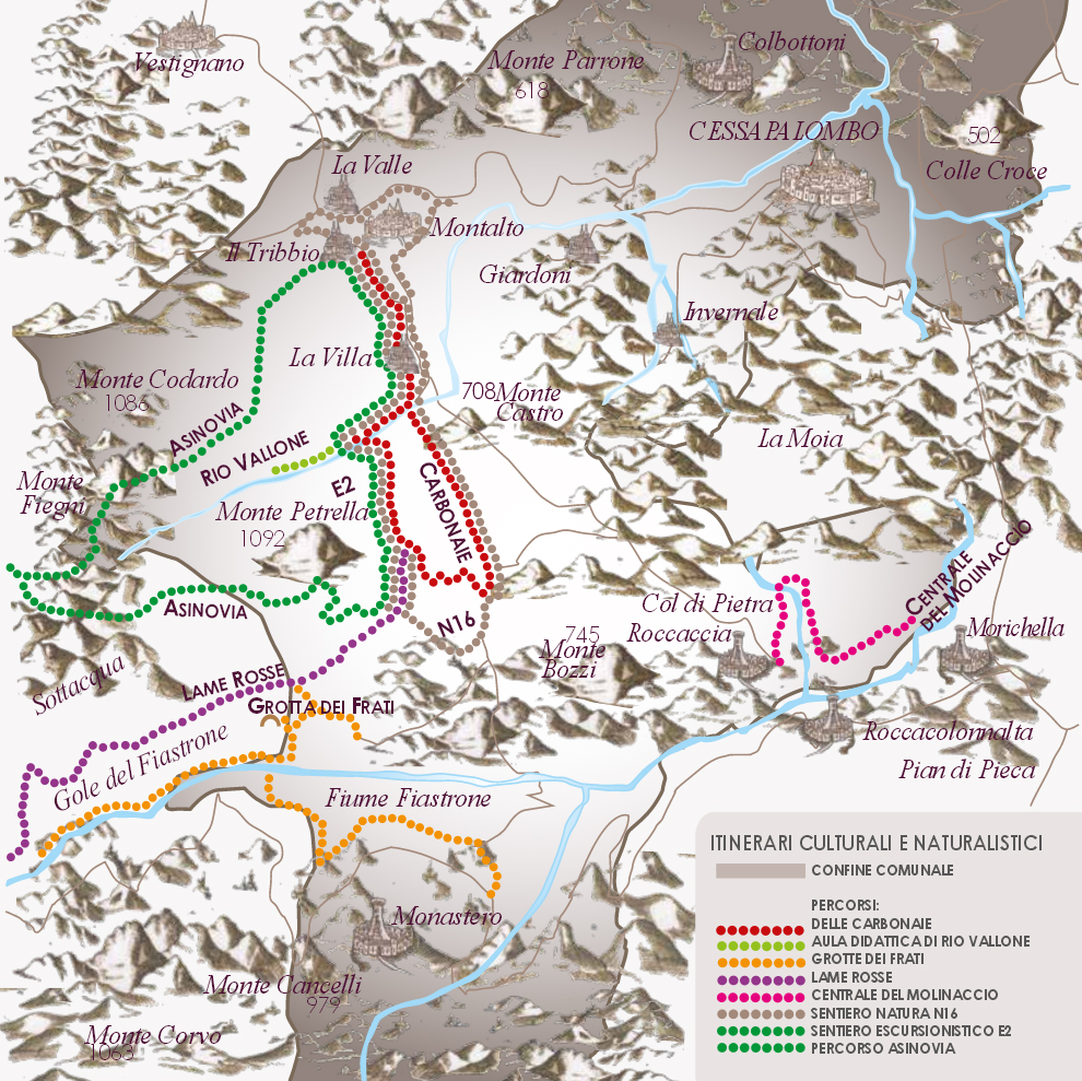
Another example of flora and fauna is the Rio Vallone Teaching Centre a gorge of geological interest carved out by the Vallone river. The route is shown in the picture paneling.
Nature pathway N°16 “Ancient woodland rejuvenated” easily accessed. From Palazzo Simonelli, townland of Tribbio, go into the wood on the right, just after leaving the fencing of “Casa e Giardino delle Farfalle”, it comes out near the houses in Villa, touches the Vallone river teaching centre and following a ringed route,it goes back in the direction of Tribbio.
The nature pathway intersects the white vehicle-accessible road that leads to the Grotta dei Frati carpark and the Fiastrone Gorges. Even though these two places do not fall under the jurisdiction of the local authority, they are easily accessible from the hamlet of Villa, thus they are advised. What’s more, the nature pathway intersects the hill to Monte Petrella too, and which in turn meets the entrance for the Carbonaie pathway; along which we find the “spiazzi”, used in times past, for producing coal.
Following along the path which leads to Monte Petrella, we find access to Lame Rosse pathway, within the local area of Fiastra; natural red sandstone formations prone to landslides. Landslides and erosion give rise to a veritable Canyon with changing and fascinating rock formations.
E2 Pathway a route of a greater degree of difficulty compared to (EE Experts Only pathway), Tribbio-Monte Petrella-Tribbio, 8.2 km, height difference of 800 m, both as regards climb at start and return downhill journey.
From the residential area of Villa, we can take the white, vehicle accessible, road leading to the village of Col di Pietra and the ruins of the castle of the same name, also known as “Rocaccia”. Not far away from Col di Pietra lies the area called the “Molinaccio” where, till the forties an electrical power supply was functioning, originally from 1903 and built on a preceding watermill structure. The plant included a dam, taken down in about 1950 following the building of the Fiastra dam.
The Asinovia Route, a trail which partially retraces pathway E1, it is in a ring shape within the local authority area. This pathway was thought out to connect the Townland authority of Cessapalombo to that of Pievebovigliana. The two ring-shaped pathways join in the area known as Santa Maria Maddalena, 1,100 m above sea level, the place where the two communities traditionally come together.